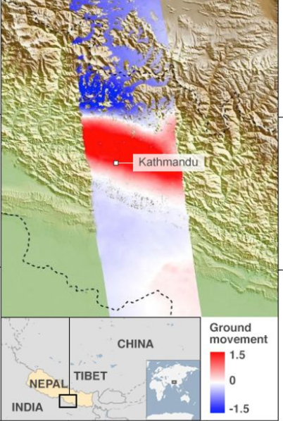
喜马拉雅山脉高度变化

The height of the Himalayas has dropped by around one metre as a result of the Nepal earthquake, scientists say. But they add that the drop will roughly be balanced by slow uplift due to tectonic activity. And they have yet to analyse satellite images of the region in which the most famous Himalayan peak - Everest - is located. However, there continues to research over exactly how tall Everest is.
The Langtang range is the region where many locals are still missing, after the landslides caused by the 7.8 magnitude earthquake on 25 April. Scientists believe the height of a handful of other Himalayan peaks, including the Ganesh Himal to the west of the Langtang range, may also have dropped. The satellite images they have analysed so far have focused on central Nepal, which was the hardest hit by the quake. Everest is to the east of this main shaking zone.
Scientists say whether or not the world's highest peak saw a change in its height by few centimetres will have to be further confirmed by ground survey. Scientists with DLR's Earth Observation Centre of compared two separate images of the same region sent by the satellite, before and after the quake. The study has also found that areas including the capital, Kathmandu, to the south of the Himalayan mountains have been uplifted by the quake.
Scientists say the drop and the uplift are normal during an earthquake of this scale. Normally, the Himalayas are on the rise because of the collision between the Indian and Eurasian tectonic plates(欧亚板块). But during major earthquakes the process gets reversed, experts say.
本时文内容由奇速英语国际教育研究院原创编写,禁止复制和任何商业用途,版权所有,侵权必究!